
Capture, manage, analyze, and share reality data in a connected reality data environment to serve as a single source of truth to advance infrastructure workflows. Turn reality data into real-world insights for your digital twins to make informed decisions.
Capture
Leverage the highest fidelity and most versatile means of capturing reality data to serve as the digital context for design and engineering, as well as construction and operations.
Manage and Share
Empower stakeholders with immediate access to reality data. Make data actionable so stakeholders get the right information at the right time to make more informed and timely decisions.
Analyze and Deliver
Turn reality data into real-world insights for data-driven decisions using artificial intelligence and machine learning. Deliver your reality data to feed your digital twins.
iTwin Capture offers the highest fidelity and most versatile means of capturing reality to serve as the digital context for design, and engineering,
construction, and operations workflows. With iTwin Capture, you can go beyond simply creating a digital twin of realworld conditions. The capability enables you to continuously update your digital twin with valuable information extracted from a variety of reality data— including photos, point clouds, and reality meshes—by leveraging automated analysis software. iTwin Capture brings reality capture to everyone, enabling all infrastructure
practitioners to access these capabilities and create, manage, and share reality data, as well as extract insights. This connected reality data environment serves as a single source of truth to advance your infrastructure workflows.
Capture, Create, and Enhance Reality Data.
With iTwin Capture, you can import any reality data to support various consumption workflows. This application enables the creation of engineering-ready reality data, including reality meshes, classified point clouds, anonymized images, and orthophotos of any size and resolution, using any digital camera, scanner, or mobile mapping device. Enhance your reality data with advanced features such as masks, water constraints, and advanced retouching capabilities. iTwin Capture reliably and quickly produces high-quality reality meshes, from objects a few centimeters in size to entire cities, with precision limited only by the image resolution.
Cloud-powered workflows in iTwin Capture simplify and scale your projects, allowing team members to easily document as-is situations affordably and with less time and resource investment, thereby reducing costs. Leverage parallel cloud processing capabilities to scale your production and deliver projects on time.
Manage and Share Reality Data.
iTwin Capture enables you to federate all your reality data, regardless of size or type, within a connected reality data environment. This application allows you to securely manage, store, grant user access, and share large volumes of reality data with authorized stakeholders on any device. By working in a connected data environment, you can enhance your workflow through the instant sharing and syncing of reality data across project teams and applications. This ensures everyone receives the right information at the right time, facilitating more informed and timely decisions. By organizing, cataloging, and indexing your reality data, you can perform effective searches and accelerate your workflows.
Reality Data Perfection.
Visually evaluate the quality of your reality data using control alignment and dimensions with a dedicated application before transferring it to engineering and operations teams. By leveraging artificial intelligence and machine learning, you can unlock the full potential of your reality data, transforming it into actionable real-world insights for data-driven decisions. Automated feature extraction and defect detection, along with efficient asset inventory and feature extraction workflows, can save you hours of tedious work. Deliver your reality data in engineering-ready formats for use in any CAD or GIS workflow or with the iTwin Platform.
MINIMUM: 8 GB of RAM, NVIDIA, AMD or Intel GPU, Microsoft Windows 10/11 (64 bit) or Microsoft Windows Server 2012/2016/2019 (64 bit)
RECOMMENDED: 64 GB of RAM, NVIDIA GeForce RTX 2080Ti GPU, Intel 9-4.0GHz CPU, Microsoft Windows 10/11 (64 bit) or Microsoft Windows
Server 2012/2016/2019 (64 bit)
BROWSER COMPATIBILITY: Edge, Chrome, and Firefox
Reality Mesh Processing
– Import reality data of any type (image, point cloud, video) in various formats
– Create reality meshes, orthophotos, and point clouds
– Ensure accurate georegistration by handling RTK-GPS or ground control points
– Leverage unique parallel computing to reach unmatched processing speed
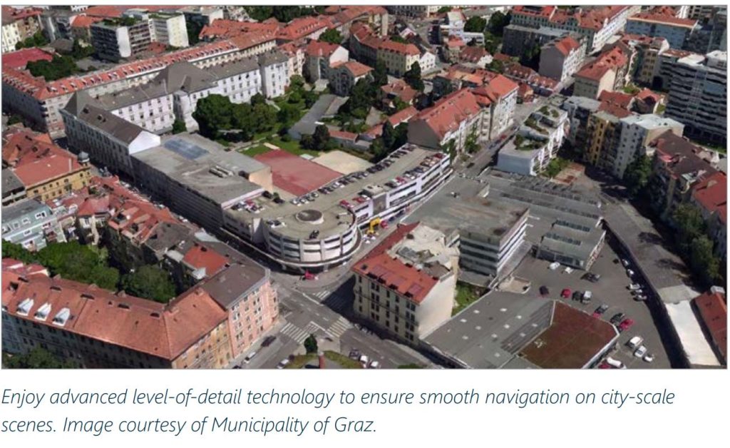
– Enjoy advanced level-of-detail technology to ensure smooth navigation on city-scale scenes
Reality Data Conversion
– Transform point cloud data optimized for web-streaming to support your downstream operations
Reality Data Management and Sharing
– Share images, point clouds, and meshes straight from user interface and invite all project stakeholders to collaborate in single environment
– Manage access rights and levels of permission to secure the project environment
– Import, manage, and align reality data of any type in a simple, streamlined way using a wide range of predefined templates
– Refine reality data quality by removing extra “noise,” such as people or vehicles, merging sub-parts, or correcting positional accuracy
Insight and Features Extraction
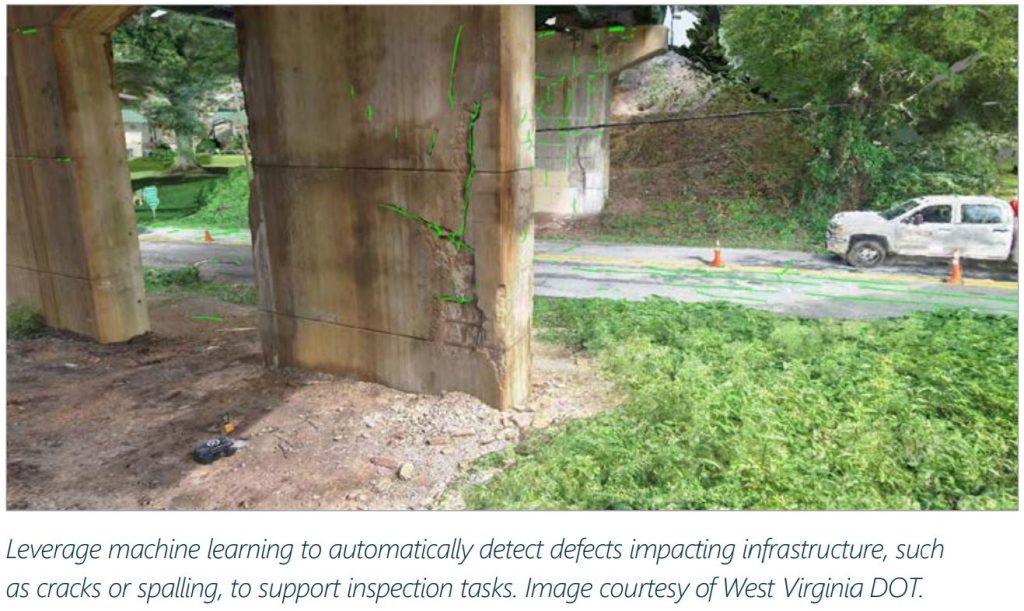
– Leverage machine learning to automatically highlight defects impacting infrastructure to support inspection tasks (cracks, spalling)
– Define ground occupation of your 3D scenes, such as terrain or roofs
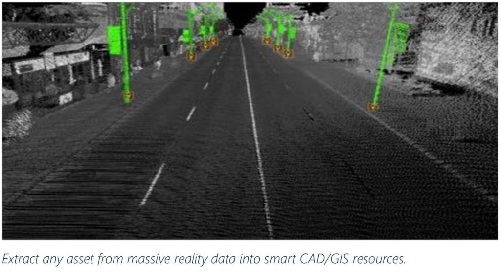
– Extract any asset from massive reality data into smart CAD/GIS resources
– Verify quality control extracted features and run advanced quality assessment
– Leverage profiles and cross-sections, bridge clearance, and clash detection to perform and report deep analysis using reality data
Validation and Delivery
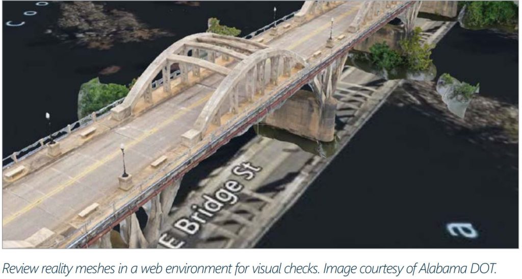
– Review reality data (images, point clouds, and meshes) in a web environment for visual checks
– Assess quality of alignment with open mapping layers
– Verify dimensions with coordinates, length, or area measurement capabilities prior to delivery

Contact Us
SOHO Pancoran, South Jakarta
Block Splendor Wing, 28th Floor
Unit S-2803, South Jakarta, 12810